Tell Rifaat: An Ancient Archaeological Site in Northern Syria
Tell Rifaat is an ancient archaeological site in northern Syria. It is known for its long history and layers of remains from multiple civilizations. Today, Tell Rifaat stands as both a living town and a significant archaeological mound in the countryside of Aleppo.
Although many people associate the town with recent conflicts, its deeper history tells a very different story. Beneath the modern settlement lie the remains of Arpad, a powerful ancient city that once shaped Iron Age politics in the Near East.
A City with Deep Roots: The History of Tell Rifaat
Tell Rifaat in the Aramaean Period
The history of Arpad, stretches back more than 3,000 years. During the Iron Age, the site was known as Arpad, the capital of the Aramaean kingdom of Bit Agusi. This state emerged in the 9th century BCE under the rule of Gus of Yakhan.
Bit Agusi controlled a wide territory in northern Syria. Its lands extended from the Azaz region in the north to Hamath in the south. Because of this, Arpad became a major political and military center.
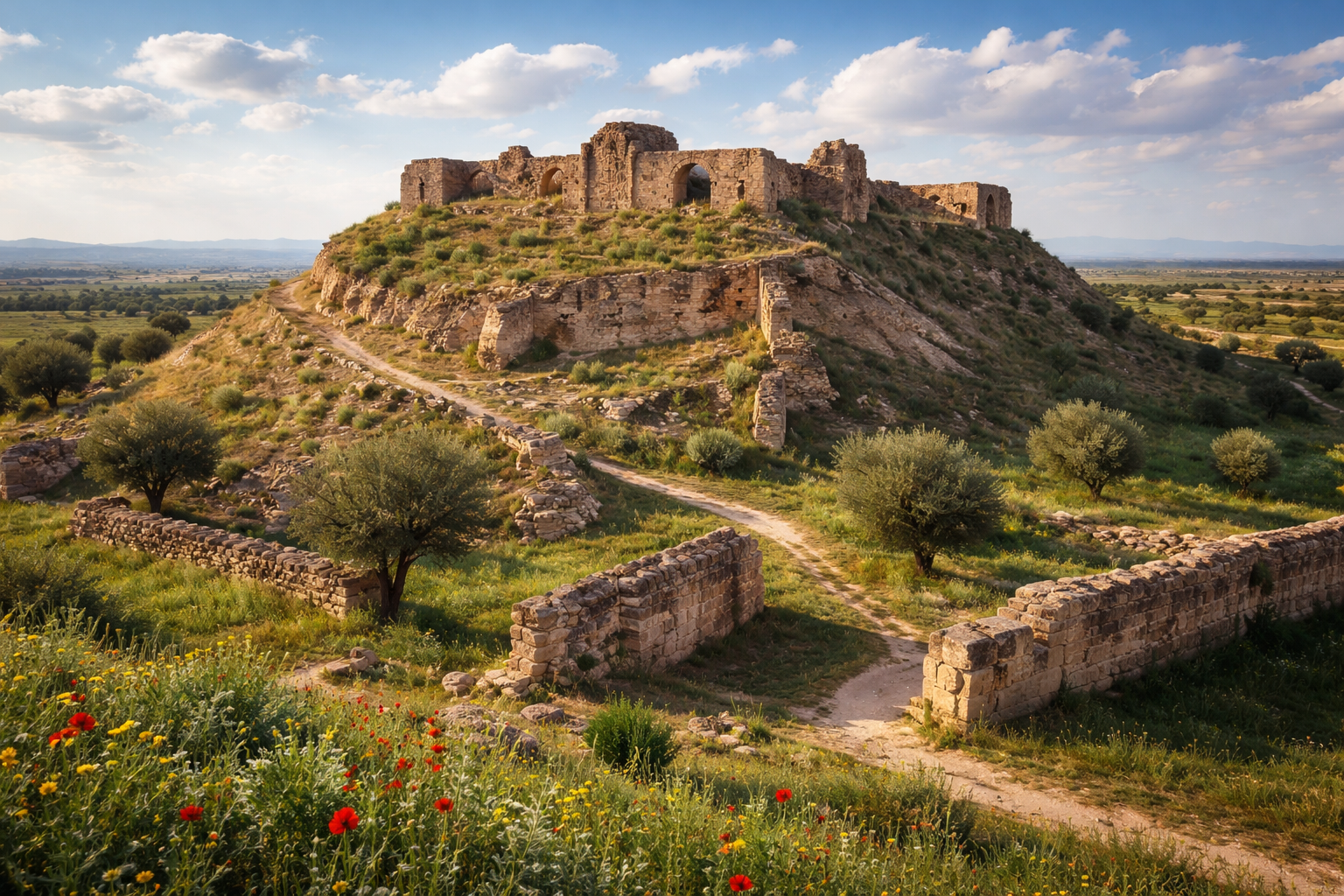
Arpad’s importance also came from its strategic location. It stood along key regional routes and was protected by strong fortifications. Parts of its defensive walls still survive today, rising up to eight meters in height.
Siege and Assyrian Conquest of Tell Rifaat
However, Arpad’s strength also attracted powerful enemies. In 743 BCE, the Assyrian king Tiglath-Pileser III launched a major campaign against the city. This attack occurred during wider conflicts between Assyria and Urartu.
Historical sources indicate that the Assyrians besieged Arpad for several years. Eventually, they captured the city. After its fall, Arpad lost its independence and became an Assyrian provincial capital. As a result, the balance of power in the region shifted dramatically.
Tell Rifaat During the Classical and Hellenistic Periods
Despite the Assyrian conquest, occupation at Arpad, did not end. Archaeological evidence shows continued settlement during later periods. In particular, the site remained active during the Hellenistic era, under the Seleucid Empire between roughly 301 and 63 BCE.
Finds such as coin hoards from this period confirm ongoing habitation and trade. Therefore, Tell Rifaat continued to play a regional role long after Aramaean rule disappeared.
Modern History of Tell Rifaat
In later centuries, the site remained inhabited, though its role changed. Under Ottoman rule, the settlement became known as Tell Rifaat, and a village gradually developed around the ancient mound. Over time, this village grew into a town.
In the 21st century, Tell Rifaat became heavily affected by the Syrian Civil War. The town experienced sieges, shifts in control, bombardment, and large-scale displacement. As a result, much of the modern infrastructure suffered severe damage.
Today, returning residents face major challenges. These include rebuilding homes and dealing with hidden dangers, such as tunnels and unexploded remnants left behind from wartime defenses.
The Archaeological Site of Tell Rifaat Today
The archaeological mound of Tell Rifaat is oval in shape. It measures roughly 250 × 233 meters. At its center lies the main citadel, which covers about 142 × 142 meters and rises to a height of nearly 30 meters.
Excavations at the site have revealed multiple layers of occupation. These layers reflect centuries of human activity, spanning Aramaean, Assyrian, Hellenistic, and later periods. Together, they confirm Tell Rifaat’s long and complex role in the history of northern Syria.

Fortifications and Urban Structure of Tell Rifaat
One of the most striking features of Tell Rifaat is its massive defensive system. The Iron Age walls remain visible across large sections of the site and clearly demonstrate the city’s military strength. These fortifications reflect a high level of planning and long-term strategic thinking.
In addition, archaeological evidence points to a double gate complex reinforced with semi-cylindrical towers. This layout highlights not only the defensive role of the city but also its administrative importance as a regional center.
Moreover, researchers believe that an underground water channel played a crucial role in the city’s survival during prolonged sieges. This hidden infrastructure allowed access to water even when the city was surrounded. Such a system represents a rare and sophisticated example of ancient engineering in northern Syria.
Excavations and Research at Tell Rifaat
Archaeological research at Tell Rifaat began in earnest in the mid-20th century. Early surveys and excavations took place during the 1950s and 1960s. These efforts involved several international teams, including specialists from the University of London’s Institute of Archaeology.
Later, during the 1970s, additional regional surveys expanded scholarly understanding of settlement patterns around the site. These studies placed Tell Rifaat within a broader network of Iron Age and Classical communities in northern Syria.
More recently, documentation methods have evolved. Archaeologists have used drone-based photogrammetry to create detailed 3D models of the mound. These digital reconstructions are intended for display in the virtual Aleppo Museum. As a result, Tell Rifaat’s heritage can now reach global audiences despite limited physical access.
Why Tell Rifaat Matters
Tell Rifaat holds importance on several interconnected levels.
Historical and Cultural Importance
As the probable location of ancient Arpad, Tell Rifaat was one of the most influential cities in northern Syria during the Iron Age. It interacted with major regional powers, including Assyria and Urartu. Its fortifications and urban organization provide valuable insight into ancient political authority and military strategy in the Near East.
Archaeological Value
The site preserves rich and layered archaeological deposits. These strata reflect continuous occupation from early Iron Age state formation through Classical antiquity. Artifacts from different periods help scholars reconstruct daily life, trade networks, and cultural exchange over many centuries.
Educational and Heritage Potential
Despite damage caused by modern conflict, Tell Rifaat remains essential for research into ancient Near Eastern history. Ongoing documentation and digital preservation projects ensure that the site’s historical legacy will continue to inform future generations.
How to Reach Tell Rifaat
Tell Rifaat is located in northern Aleppo Governorate. It lies approximately 40 km (25 miles) north of Aleppo city and about 20 km (12 miles) south of the Turkish border. Its approximate coordinates are 36°28′ N, 37°06′ E.
By Road
When conditions allow, travelers usually reach Tell Rifaat by road from Aleppo. The route follows northern regional highways toward the Azaz area before turning east toward the town. However, because the region has experienced prolonged conflict, it is essential to consult updated travel advisories and security information before planning any visit.
Video about Tal Rifaat al-Athar on our YouTube channel
Local Guidance and Transport
Given the complexities of the surrounding region, visitors — especially researchers — often coordinate with local authorities, archaeological missions, or international organizations engaged in heritage preservation. These groups can provide logistical support and up-to-date information on access and safety.
Qal’at Simaan (Castle of Saint Simeon): History and Facts About the Ancient Site in Syria
Conclusion
Tell Rifaat may not be a household name like Palmyra or Ebla, but its role as the ancient city of Arpad makes it a site of profound historical resonance. From its Iron Age grandeur through centuries of settlement, decline, and survival into the present day, Tell Rifaat embodies the depth and durability of Syrian heritage. Whether you’re a history enthusiast, an archaeologist, or simply a curious traveler, discovering the story beneath this modest mound offers a window into a distant past that shaped the ancient Near East.
Aleppo: History, Culture and Facts About Syria’s Oldest Cities
Leave a Reply